Screenshots

About this app
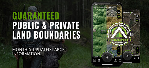
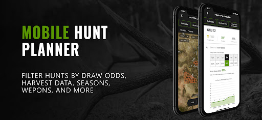
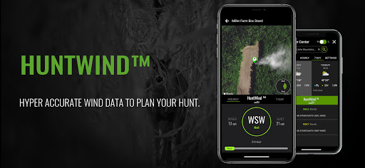
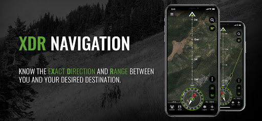
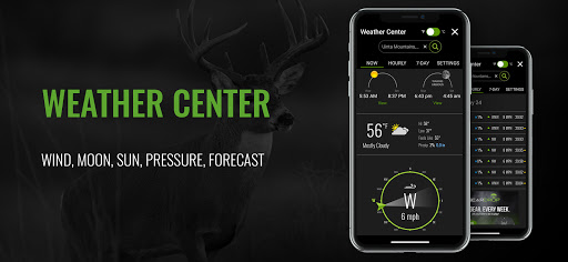
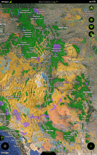
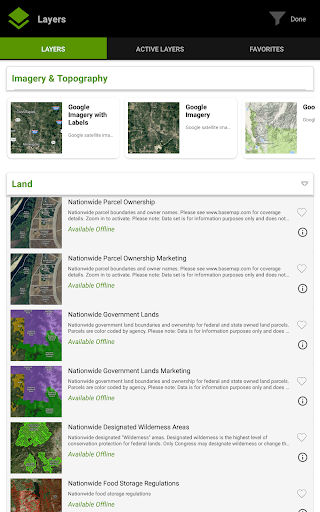
Land ownership maps, hunt planning, navigation, GPS, wind, weather, and field tools all in one convenient app. OFFLINE GPS and TRACKING • Save maps for offline use without service • Know exactly where you are in real time even without cellular coverage MAP LAYERS • 900 layers and growing • Nationwide Color Coded Govt Lands • Nationwide Private Parcel Boundaries & Owner Names • Coastal Water Depths & over 4,000 U.S. lakes • Nationwide Hiking Trails • Nationwide Wildfires & Timber cuts • Nationwide Wilderness & Roadless Areas • State hunting layers (boundaries, WMA’s, habitat, etc) • Multiple Topography & Satellite Imagery basemap options • Much more DESKTOP & MOBILE HUNT PLANNER • Unit filtering • Draw odds • Harvest data • Season dates • Unit insights LRF MAPPING (Laser Rangefinder Mapping) • Use your rangefinder as a powerful mapping tool • Precisely mark the exact location of distant targets with ANY rangefinder • Recover game, plan stalks, lookup distant property owners and more, all using your rangefinder MOBILE GPS • Know your exact location even without cellular or WiFi service • See where you are in relation to landmarks, boundaries, roads, trails, etc • Navigate to trailheads, favorite places, markers, or anything you need to locate with our powerful Search and GoTo features. XDR (Exact Direction & Range) NAVIGATION TOOL • Easy Point and Go navigation • Know the exact distance between you and your destination. HUNTWIND & WEATHER CENTER • Wind forecast to better plan your hunt. • Know the exact day and time to hunt a particular stand and visualize wind direction and scent drift in relation to your location. • Forecasts, temperature, moon phase, sunrise/sunset, wind, and more. LOCATION SHARING • Know exactly where your hunting partner is located • Real-time updates OUTDOOR JOURNAL • Capture, log, and share all your outdoor adventures with the BaseMap community • Real-time location sharing so friends can see where you are in case of emergency (connection reqd.) • SmartMarkers - Automatically capture the weather conditions at the time you add a marker. • HARVEST LOG • Log your hunts as detailed as you'd like. Record your hunt type, species/size, weapon, unit/GMU & much more. GOOGLE EARTH INTEGRATION • Export markers and view them right in Google Earth • View the terrain in true 3D SUBSCRIPTIONS BASIC (Free) • No Ads • Connect with friends • Hybrid 3D Imagery (map tilt). • XDR Navigation • Nationwide Roads, Trails & Points of Interest • Nationwide Lakes, Rivers & Streams • Hunting Unit boundaries • GPS Location & Tracking • Hi-Res Satellite Imagery PRO ($39.99/yr) • Everything in Basic plan • Access to over 800 Layers • Unlimited Data & Offline Use • Nationwide parcel boundaries and owner names • Nationwide color-coded government lands • Google Earth Integration • Import/Export KML and GPX with BaseMap web application • Real-Time location sharing • LRF Mapping (Laser Rangefinder Mapping) • Discounted private land hunts PRO ADVANTAGE ($69.99/yr) • BaseMap Pro subscription • Discounted private land hunts • Global Rescue field advisory and rescue services PRO ULTIMATE ($99.99/yr) Includes: • BaseMap Pro • Discounted private land hunts • Global Rescue field advisory and rescue services • Hunt Planner: Unit filtering, draw odds, harvest data, season dates, and more For questions, contact us at: support@basemap.com Privacy policy: https://www.basemap.com/privacy-policy/ Terms of use: https://www.basemap.com/terms-of-use/ Government Information: BaseMap Inc does not represent any government or political entity, though you may find various links to public information within our services. For more info on any government information found within the services, click on the associated .gov link. https://data.fs.usda.gov/geodata/ https://gbp-blm-egis.hub.arcgis.com/
What's New
Latest version 6.1.1 with bug fixes and performance improvements
Enhanced security and stability
Optimized for better user experience
Kullanıcı Yorumları
10 yorumA Google user
6 yıl önce
Excellent app. Easy to use, runs fast and is responsive whether online or offline, and has tons of layers for just about anything you could need for hiking, hunting, fishing, mountain biking, offroading, or anything else that takes you away from paved roads or cell reception. The premium subscription is well worth it and is priced very reasonably for what it provides.
Thank you for the review and for using BaseMap!
Wayne
2 yıl önce
If you are looking for a really good hunting app, this is it ! I have the other popular hunting apps on my phone, but Basemap is the only one I use now. This app stays up to date better than the others. I pulled up the satellite on all 4 of the apps and basemap was the only one that had the current aerial photos of my farm and the other 3 apps were all at least 3 months behind on the aerial/satellite photos of my farm. I know this as fact because of where my vehicles and tractors were parked.
A Google user
7 yıl önce
I split time using this app as well as a competing maps app last fall while hunting. I am very impressed with Basemap's crisp map imaging and it seemed to be spot on with GPS location, even without having cell service. I do need to play around with the app more because I felt like I needed to re-learn some of the menu options. Overall, I am happy with the app, just felt hung up trying to find what I needed. Will tell people to give it a try because it is cheaper than other options
Thank you for the review and for using BaseMap!
Developer
Trusted developer with verified applications on our platform.
App Information
Download Stats
Safe Download
This app has been verified and is safe to download. No malware detected.
You Might Also Like
More apps from Sports category